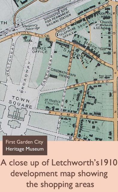
In Letchworth, Parker and Unwin had planned shopping streets called Eastcheap and Westcheap to run parallel with The Broadway. But the first shopping streets developed close to the town’s early residents. Station Road and Leys Avenue became the town’s first two shopping streets near to the residents of Birds Hill and the 1905 Cheap Cottages. The first shops were built on Station Road from 1906.
Added:
29th Aug 2009
Subjects:
Geography, History
Key Stages:
Key Stage 1, Key Stage 2, Key Stage 3, Key Stage 4
Keywords:
map, shopping, shops, Letchworth, garden city, development
Related Links:
EXIF data:| FILE |
| FileName | 1910_dev_map_close_up.jpg |
| FileDateTime | 0 |
| FileSize | 147739 |
| FileType | 2 |
| MimeType | image/jpeg |
| SectionsFound | ANY_TAG, IFD0, THUMBNAIL, EXIF |
| COMPUTED |
| html | width="547" height="888" |
| Height | 888 |
| Width | 547 |
| IsColor | 1 |
| ByteOrderMotorola | 0 |
| Thumbnail.FileType | 2 |
| Thumbnail.MimeType | image/jpeg |
| IFD0 |
| ImageDescription | Tom_Jones 027 |
| Orientation | 1 |
| XResolution | 3000000/10000 |
| YResolution | 3000000/10000 |
| ResolutionUnit | 2 |
| Software | Adobe Photoshop CS2 Windows |
| DateTime | 2009:08:28 15:19:30 |
| Exif_IFD_Pointer | 188 |
| THUMBNAIL |
| Compression | 6 |
| XResolution | 72/1 |
| YResolution | 72/1 |
| ResolutionUnit | 2 |
| JPEGInterchangeFormat | 326 |
| JPEGInterchangeFormatLength | 8139 |
| EXIF |
| ColorSpace | 65535 |
| ExifImageWidth | 547 |
| ExifImageLength | 888 |
 Close up of Letchworth's development map, 1910

 [ 1 ]
[ 1 ]  [
[

