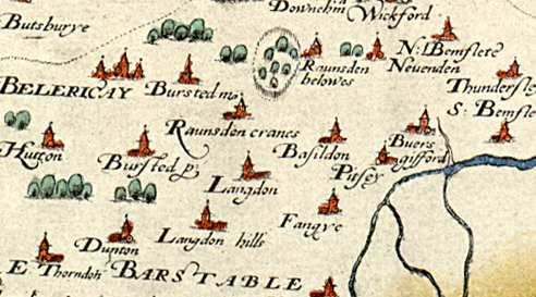
This is part of a map made in 1576. Note how some of the place names are spelt. The letter that looks like a long “f” in Pitsey and Basildon is in fact an “s”. In the name Buers Gifford, the letters are “f”. if you look carefully you can see there is a difference.
Other places have changed their names slightly. Raunsden belowes on the map is now Ramsden Bellhouse (in 1208 it belonged to Ricardus de Belhus). Billericay was Belericay. Vange appears as Fangye.
Discuss and record
Why do you think no roads are shown? There is a small picture by most of the village names; what is it of? In most cases it’s more or less the same image – why?
Compare with a modern map of the area
Added:
26th Sep 2008
Subjects:
Geography, History
Key Stages:
Key Stage 2, Key Stage 3, Key Stage 4
Keywords:
Basildon, local history, Tudor, map
Related Links:
EXIF data:| FILE |
| FileName | christopher_saxton_1576.jpg |
| FileDateTime | 0 |
| FileSize | 221079 |
| FileType | 2 |
| MimeType | image/jpeg |
| SectionsFound | ANY_TAG, IFD0, THUMBNAIL, EXIF |
| COMPUTED |
| html | width="492" height="273" |
| Height | 273 |
| Width | 492 |
| IsColor | 1 |
| ByteOrderMotorola | 1 |
| Thumbnail.FileType | 2 |
| Thumbnail.MimeType | image/jpeg |
| IFD0 |
| Orientation | 1 |
| XResolution | 300/1 |
| YResolution | 300/1 |
| ResolutionUnit | 2 |
| Software | Adobe Photoshop 7.0 |
| DateTime | 2008:09:26 11:08:44 |
| Artist | � |
| Exif_IFD_Pointer | 168 |
| THUMBNAIL |
| Compression | 6 |
| XResolution | 72/1 |
| YResolution | 72/1 |
| ResolutionUnit | 2 |
| JPEGInterchangeFormat | 306 |
| JPEGInterchangeFormatLength | 5572 |
| EXIF |
| ColorSpace | 65535 |
| ExifImageWidth | 492 |
| ExifImageLength | 273 |

 [ 1 ]
[ 1 ]  [
[
 1576 Essex map