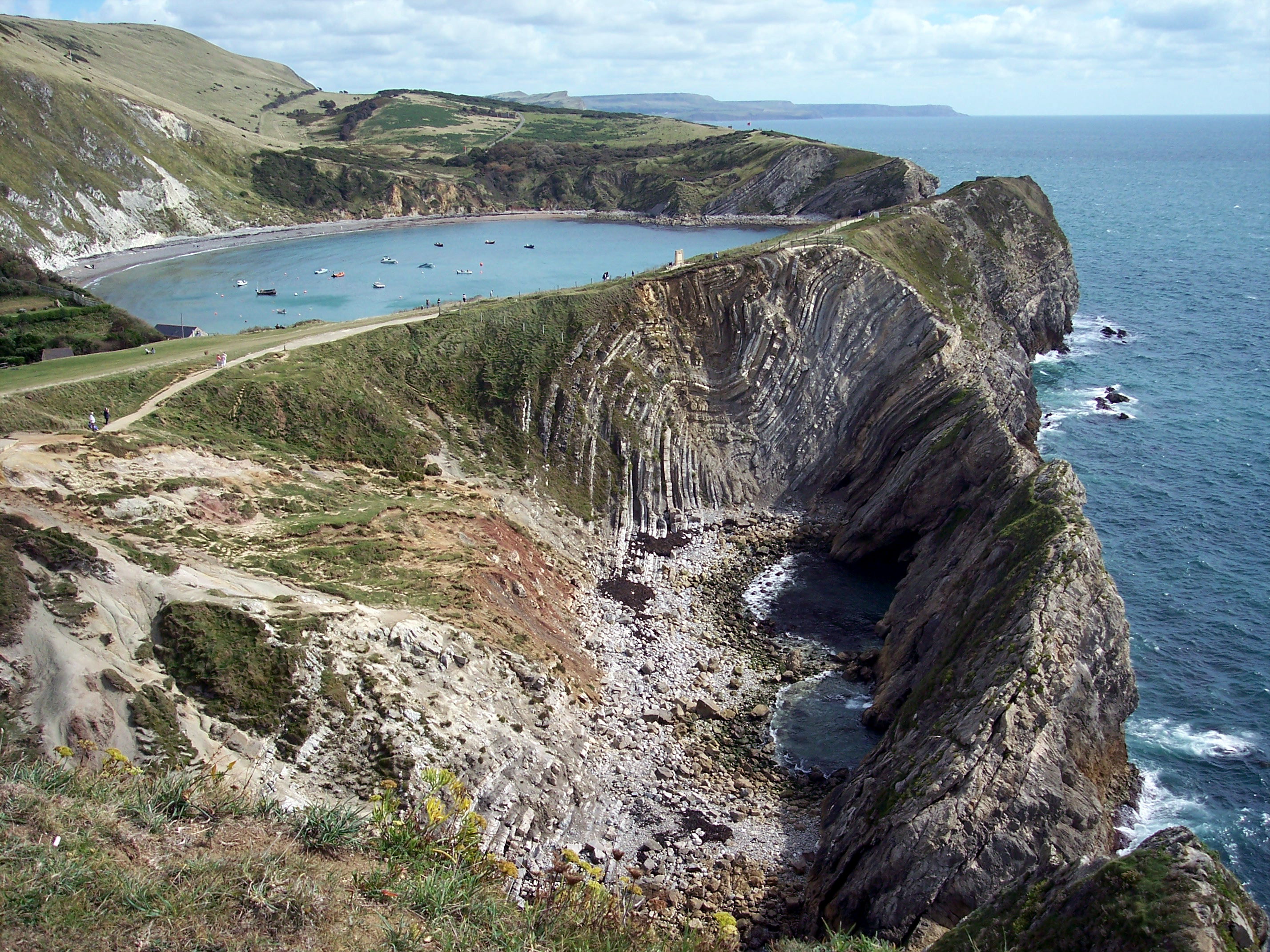
The area of Purbeck sits in a dip known as the Purbeck Monocline. Major movements of the earth's plates caused this monocline as the beds at Lulworth were lifted. Faults in the rock strata responded to the pressure of the uplift causing the rocks to twist and fold creating formations that are clearly visible. This picture was taken from a high viewpoint to the west of the cove. Weathering and erosion by streams, the sea and man have also impacted on the landscape causing the dramatic scenery.
Added:
7th Dec 2005 by Diane Earl
Subjects:
Geography, Science
Key Stages:
Key Stage 3, Key Stage 4, Key Stage 4+
EXIF data:| FILE |
| FileName | Dorsetcoastelul0020a.jpg |
| FileDateTime | 0 |
| FileSize | 4363024 |
| FileType | 2 |
| MimeType | image/jpeg |
| SectionsFound | ANY_TAG, IFD0, THUMBNAIL, EXIF |
| COMPUTED |
| html | width="2856" height="2142" |
| Height | 2142 |
| Width | 2856 |
| IsColor | 1 |
| ByteOrderMotorola | 1 |
| ApertureFNumber | f/4.0 |
| Thumbnail.FileType | 2 |
| Thumbnail.MimeType | image/jpeg |
| IFD0 |
| Make | EASTMAN KODAK COMPANY |
| Model | KODAK DX7630 ZOOM DIGITAL CAMERA |
| Orientation | 1 |
| XResolution | 230/1 |
| YResolution | 230/1 |
| ResolutionUnit | 2 |
| Software | Adobe Photoshop Elements 2.0 |
| DateTime | 2005:01:21 22:26:18 |
| YCbCrPositioning | 1 |
| Exif_IFD_Pointer | 256 |
| THUMBNAIL |
| Compression | 6 |
| XResolution | 72/1 |
| YResolution | 72/1 |
| ResolutionUnit | 2 |
| JPEGInterchangeFormat | 890 |
| JPEGInterchangeFormatLength | 5375 |
| EXIF |
| ExposureTime | 1/750 |
| FNumber | 4/1 |
| ExposureProgram | 2 |
| ISOSpeedRatings | 100 |
| ExifVersion | 0221 |
| DateTimeOriginal | 2004:09:16 13:40:49 |
| DateTimeDigitized | 2004:09:16 13:40:49 |
| ComponentsConfiguration | ���� |
| ShutterSpeedValue | 95/10 |
| ApertureValue | 4/1 |
| ExposureBiasValue | 0/10 |
| MaxApertureValue | 3/1 |
| MeteringMode | 5 |
| LightSource | 0 |
| Flash | 24 |
| FocalLength | 80/10 |
| FlashPixVersion | 0100 |
| ColorSpace | 1 |
| ExifImageWidth | 2856 |
| ExifImageLength | 2142 |
| ExposureIndex | 100/1 |
| SensingMethod | 2 |
| FileSource | � |
| SceneType | � |
| CustomRendered | 0 |
| ExposureMode | 0 |
| WhiteBalance | 0 |
| DigitalZoomRatio | 0/100 |
| FocalLengthIn35mmFilm | 39 |
| SceneCaptureType | 0 |
| GainControl | 0 |
| Contrast | 0 |
| Saturation | 0 |
| Sharpness | 0 |
| SubjectDistanceRange | 0 |

 [ 1 ]
[ 1 ]  [
[
 Lulworth Cove - Folding of the Rocks